ANALYTICS & RESEARCH
How does NYC lose housing?
In the midst of a housing crisis, it is important to understand exactly how, and where, NYC is losing housing units. Using DOB permit data, I analyzed thousands of construction projects to understand how demolitions, conversions, and combining apartments effects NYC’s housing supply.
Download the info brief here
Where does new construction happen in NYC?
For this analysis, I used a linear probability model to examine the relationships between new development and land use regulations, physical site constraints, and ownership in New York City.
Download the full article here
Informal settlements & the right to the city in Kampala, Uganda
For this research, I travelled to Kampala, Uganda to interview individuals living in informal settlements and conduct research on the housing and economic development policies within the country. This work was published in The Geographical Bulletin in May 2015.
Full article available in The Geographical Bulletin
Where are new apartments being built in NYC?
Using Python to analyze construction permit data, I sought to understand where new dwelling units were being built throughout New York City. Specifically, I answered the question: which neighborhood has had the most dwelling units permitted in the past 10 years?
Downtown Newark crime falls after SID Expansion
Using data from the Newark Police Department, I analyzed crime rates within Downtown Newark, finding that as the boundaries of the Special Improvement District expanded, crime fell.
Full article available on NJ.com
Downtown Newark development
Working with developers, real estate brokers, and analysts, I created a database and interactive map to show the extent of real estate development occurring in Downtown Newark.
Language Assistance Plan in Chicago
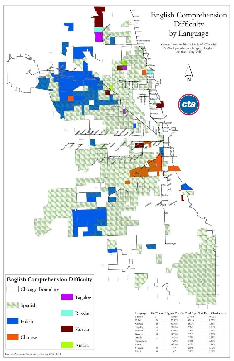
As part of the Chicago's Transit Authority's "Language Assistance Plan," I analyzed census tracts within CTA's service area where over 5% of the population have self-reported difficulty speaking English. This analysis helped inform into which languages the CTA would translate its instructions on station kiosks and informational materials.
In 2013, there were 491 census tracts that fall into this category representing 9 different languages.
Nutria Alley activation in Newark
Currently gated on all sides, Nutria Alley is an underutilized public right of way in downtown Newark and haven for illegitimate uses. In May 2017, I spearheaded an initiative to solicit ideas from over 250 members of the community on how to transform the underutilized alley into an activate public space.
Click here to find the activation plan that resulted from this engagement.
Rail ridership model for Chicago Transit Authority
Every month, CTA tracks ridership changes by comparing each month to the same month in the previous year.
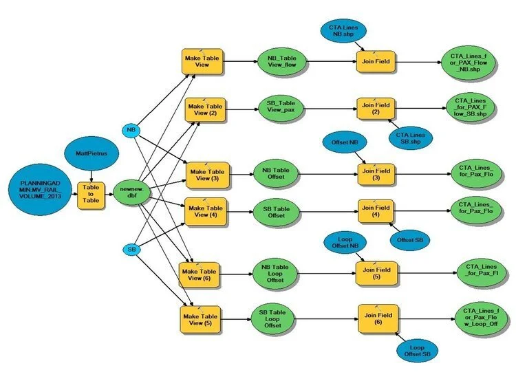
To create these maps and complete this analysis, I created a model within ArcGIS that joined new data with an existing dataset and symbolized changes the first map shown here.
Chicago inequities
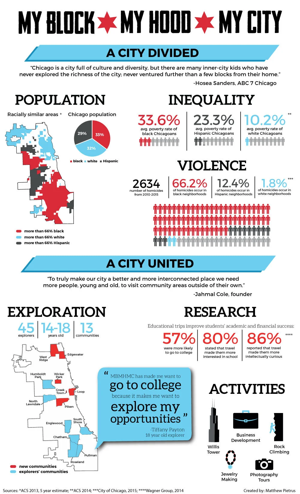
MBMHMC is an organization dedicated to expanding the experience of kids on the south and west sides of Chicago through travel. As head data analyst for the organization, I researched inequities through the city. For this work, I created an infographic to show the existing inequalities in Chicago and how the organization’s mission could reduce these inequities.
Mandela Washington Fellowship at Northwestern University
As program coordinator for President Obama's Young African Leadership Initiative, I liased with businesses, government officials, non profits, and local entrepreneurs to develop the cultural and business engagement curriculum. I was also responsible for communications, creating graphics like the infographics below.


